
- Hämta länk
- E-post
- Andra appar
På 60-talet placerade USA sina första satelliter som observerade jordens miljö. Fram till nu har dessa satelliter samlat ovärderlig information och gett nya perspektiv på jorden. Boken visar 75 satellitbilder från hela jorden. Enligt boken ska bilderna avnjutas som konst utan vetenskaplig tolkning.
"Earth As Art" - Nasa. Boken finns även i iPad utgåva. Nedan två utdrag från boken.
"Earth As Art" - Nasa. Boken finns även i iPad utgåva. Nedan två utdrag från boken.

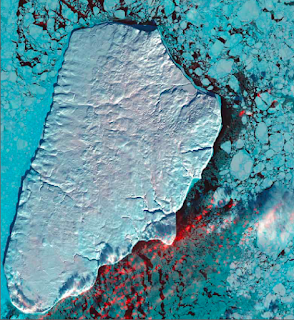
Akpatok Island rises sharply out of the frigid water of Ungava Bay in northern Quebec, Canada. Composed primarily of limestone, the island is a flat, treeless plateau 23 kilometers wide, 45 kilometers long, and about 150 to 250 meters high. This 2001 Landsat 7 image shows Akpatok Island completely covered in snow and ice. Small, dark patches of open water appear between pieces of pale blue-green sea ice, and a few scattered clouds are shown in red. The surrounding sea and ice are home to polar bears, walruses, and whales. A traditional hunting ground for native Inuit people, Akpatok is almost inaccessible except by air. The island is an important sanctuary for seabirds that make their nests in the steep cliffs that circle the island.

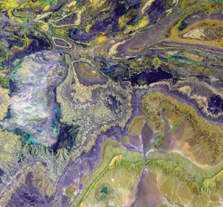
A part of the Atlas Mountains in northwest Africa, the Anti-Atlas range runs for several hundred kilometers. The range extends from the Atlantic Ocean in southwest Morocco toward the northeast, where it meets the High Atlas range closer to the Mediterranean Coast. The Anti-Atlas mountains formed as a result of continental collisions between 65 and 250 million years ago, which destroyed the then Tethys Ocean. The limestone, sandstone, claystone, and gypsum layers that formed the ocean bed were folded and crumpled to create the mountains. This Landsat 7 image from 2001 highlights some of the different rock types and illustrates the complex folding.
Kommentarer